At Ott Consulting Inc., we continuously invest in technology to enhance the accuracy and efficiency of our engineering and surveying services. Our in-house drone surveying program, operated by a Licensed Professional Land Surveyor, is a key asset in delivering high-quality results on land development and municipal projects across eastern Pennsylvania.
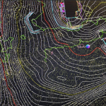
Using FAA-certified pilots and high-precision equipment—including the DJI Matrice 350 and DJI Phantom 4 Pro UAVs paired with the Rock R3 Pro V2 LiDAR system—we capture detailed topographic data across a wide range of project sites. This data is used to generate aerial base maps that serve as the foundation for design and permitting.
Our drone system provides:
- Rapid site data collection with minimal ground disturbance
- High-resolution topographic mapping using LiDAR and photogrammetry
- Enhanced safety and accessibility for large or complex sites
- Streamlined permitting through accurate and up-to-date base mapping
All flight operations are conducted under a formal safety program and FAA Part 107 certification. With over 300 hours of professional drone flight logged, our survey team uses UAVs as a trusted tool for efficient and precise mapping in both urban and environmentally sensitive areas.
Whether supporting brownfield redevelopment like the Iron Flats Apartments or municipal infrastructure upgrades, drone-based surveying allows Ott Consulting to deliver better data, faster.